Currently in Wellington. Was fucking shaky, seriously thought the building was about to collapse. This was ~500 km from the epicenter.
We were evacuated and let back in. All the planning in the world doesn't prepare you for the real thing, the first thing you're meant to do is keep calm, and I sure as hell didn't. I sprinted right the fuck out of my apartment building, I have 4 levels above me, hiding under a table wasn't going to do shit to save me.
The building has some cracks in the plaster and food has fallen off all the shelves, but nothing serious. The water seems to be running a bit brown though, so maybe some damage to the water pipes.
Props to the crew at Bizdojo (http://www.bizdojo.com/) for opening an invitation for us to come and chill there if we couldn't get back into our homes. Doing the right thing there!
    > I have 4 levels above me, hiding under a table
    > wasn't going to do shit to save me [...]  food
    > has fallen off all the shelves,
The advice to hide under tables isn't meant to save you from the entire building collapsing, but from injuries sustained from stuff falling off shelves & the non-structural parts of your roof collapsing.
Also, some tables, particularly heavy wooden and metal tables, can withstand lots and lots of weight. Hiding under them can help you avoid getting your skull bashed in by a falling slab of concrete.
The one biggish one I went through was in Seattle, where I was in a startup. We had cheap IKEA desks, which barely held the computers. I bolted for the door, which was the wrong thing to do in a brick clad building. Thankfully, we were on solid ground on Capitol Hill, not the fill in Pioneer Square, so I didn't get hit by falling cornice.
Water pipes often accumulate a layer of sediment at the bottom. Anything that stirs it up will cause brief discolouration of the water. Your pipes may be fine. (That said, I wouldn't drink the water right now.)
You get the same thing if the Fire Department uses the hydrants, for real or just to test the system.
The usual advice is to boil the water if there is any doubt. For sediment, a coffee filter first wouldn't be a terrible idea.
Edit to add: immediately after an event, if you have a tank water heater, the water in the tank was already there. If you shut off the intake valve and turn off the heater, you have enough drinking water to last for a couple of weeks. Assuming you can get a container under the drain valve on the side. Triple check you have turned off the furnace before draining any significant amount water!
I'm pretty sure Civil Defence announced it's been contaminated. I would get bottled water, and get away from the coast if you're anywhere near there, or get to high ground. If you have no other option, go to a building with reinforced concrete that's high such as a parking lot. The Tsunami warning is issued to as far as wellington, and all of the cook straight.
Yes, absolutely agreed. Last night's quake exposed my flat's somewhat chronic lack of preparation. I'll be visiting the supermarket tonight and ensuring our insurance policies are up to date, as I imagine much of Chch will be.
We've got a small collection of life straws/survival supplies for tramping, which is good, but they're in a part of the house that'd be inaccessible in a major event :/.
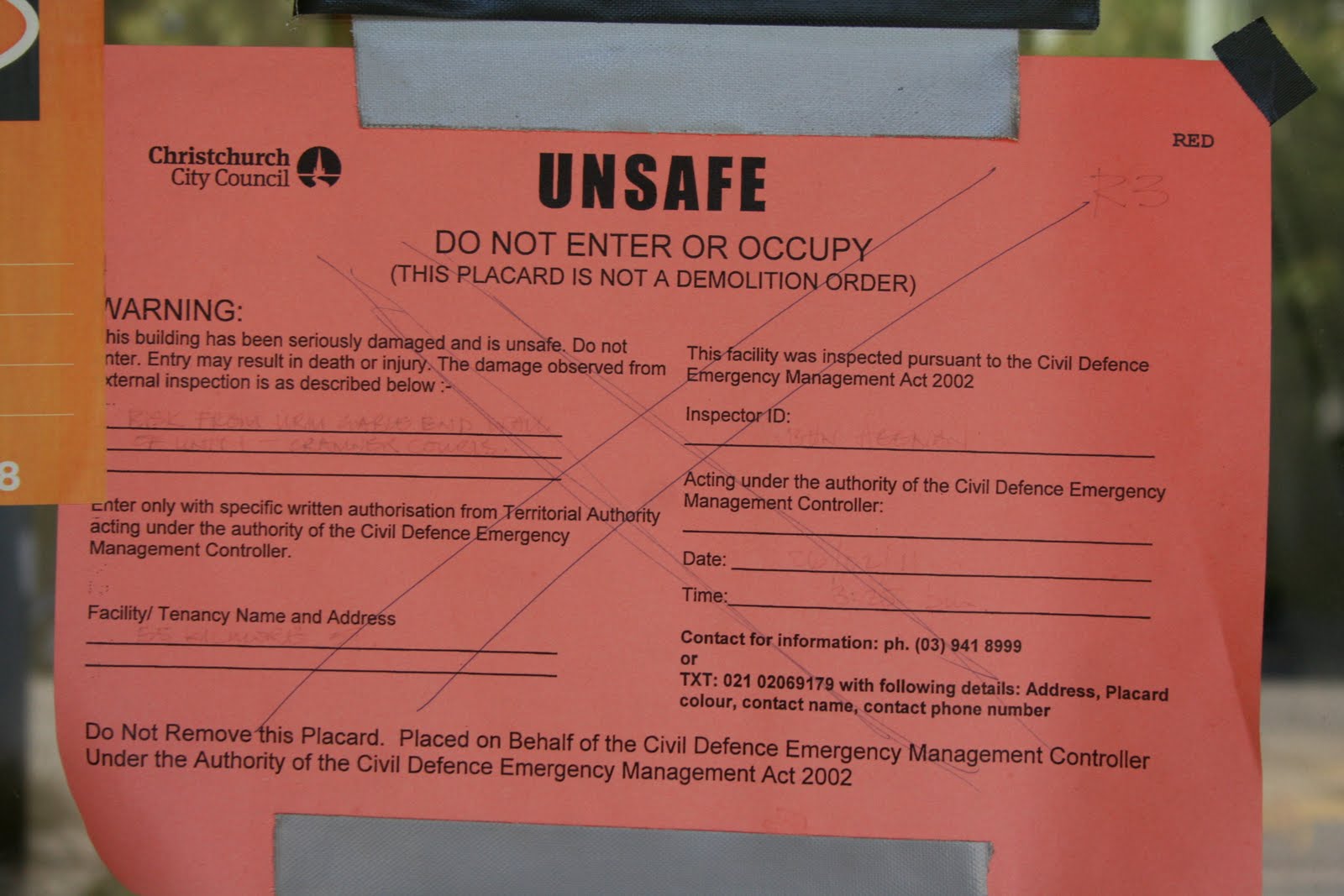
Given what ChCh went through, I really hope Wellington takes quake-proofing its more risk-prone buildings seriously. I say that every time an earthquake causes damage there, but still the building owners ask for more time and the council gives it.
A lot more buildings in Wellington are on isolaters. Parliament was retrofitted with them (huge saws cut through the concrete foundation where they were then installed). TePapa has a thing outside the museum where you can go down and see some of them.
Yeah Wellington has always taken it seriously, I remember the building where I worked in 2002 had a sticker on it by the council saying the building wasn't earthquake safe. The buildings here are much more earthquake safe than Christchurch but also the damage potential is much higher.
Only sort of. We have the whole dynamic of pushing out the date buildings are supposed to be meeting requirements, and dodgy engineers signing off on buildings that are below target NBS.
Dodgy engineers aren't going to sign off on anything because they are liable for manslaughter in the case of a catastrophe. I used to work for a structural engineering company and had to present evidence at the Royal Commission of Inquiry, engineers (at least all the ones I know) take this very seriously.
Most of the out of date buildings are empty, there are still a few empty buildings around Wellington because they don't meet code.
As far as pushing out the dates, buildings with a big sticker on them saying they are unsafe tend to struggle to find tenants, and when they do the rent has to be very cheap, so most building owners either sell the buildings or strengthen them.
And that's why the property owners have been lobbying the councils to hold off on those big stickers - because then how could they afford to do the work that they'll totally do, within X years, if the rents drop?
It looks like the quoted epicentre was just the start point of the rupture that headed off to the northeast. Which explains why the shaking seemed worse to the north and why so much activity seems to be recorded from the Seddon area again:
In Wellington it seemed like the first half was just a gentle swaying before it really kicked in for the second half. That was probably the rupture moving closer.
I found this really interesting: The USGS talks about quakes of this magnitude usually have a wide scale area of slippage eg they've modelled 200x60 km for this one:
The longest quake I've ever felt too. Some seismologists are speculating that it might actually have been two distinct quakes happening at roughly the same time.
Meh, forbes is more a problem with those pesky pre-load screens. The Verge site is a massive heap of dung even after loading. I swear every image is loaded as RAWs and then converted via JS into something edible by the browser, or some other "hipster artistry".
Magnitude 7.5 earthquake. For reference, I felt this in Hamilton, a bit under 1,000 KM away. First earthquake I have ever felt. Hamilton never, ever gets earthquakes.
Nevertheless, NZ infrastructure is built to withstand this sort of stuff. Only $100m-1b economic damage is expected, no casualties expected.
The problem with earthquakes is that damage accumulates. So while a building might stay intact or with minor damages during the main one, the aftershocks could wreck havoc. And with an 7.8 aftershocks could last for months and be quite severe.
Nevertheless I hope everyone is OK and wish you the best. I've experienced quite a few earthquakes in my life, although nothing over 7, and the shock stays for long. It's one of those times in your life when you feel completely helpless.
Yes but all multi Tennant buildings and large buildings will be inspected. We're pretty used to this and have some of thebest earthquake engineers in the world.
> Nevertheless, NZ infrastructure is built to withstand this sort of stuff
Building maybe. But our main transportation routes often have little redundancy and go through some potentially hazardous areas. State Highway 1 down the Kaikoura coast is a great example. Hopefully Lewis Pass survived ok.
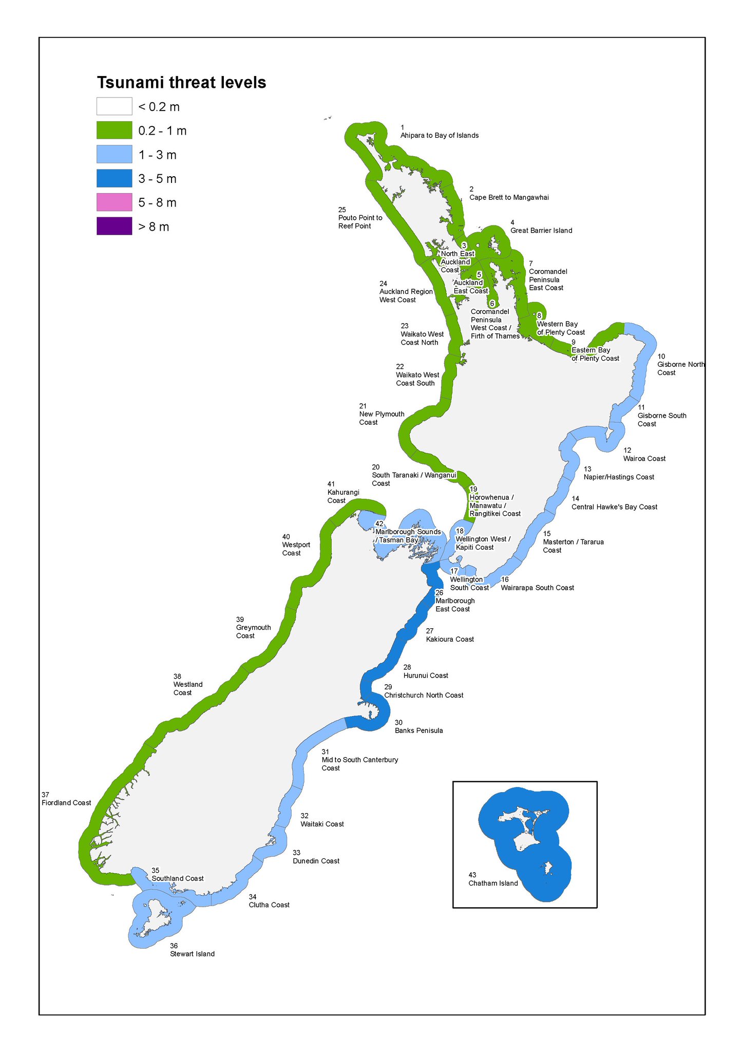
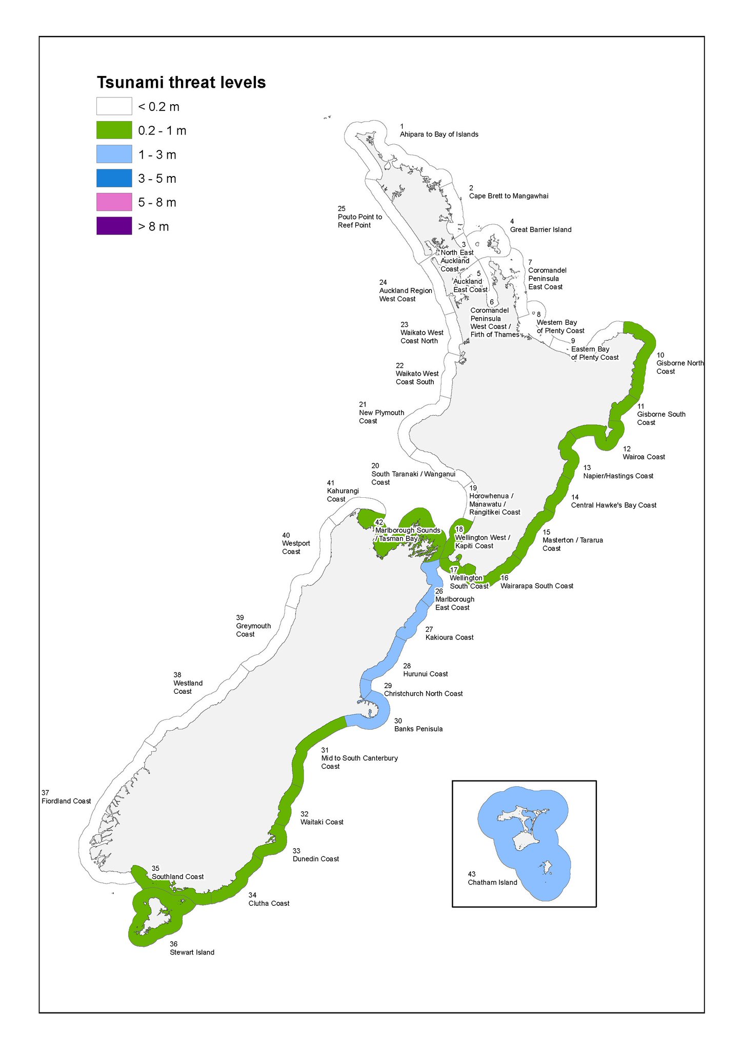
I'm from Christchurch, contacted family there. There's been mass evacuations from the coastline. Tsunami's have started but they can last for hours. Kaikoura has already had a a surge measured 2.5m, if this is the case the waves will get worse before they get better. But NZ is pretty prepared for these things, so hopefully everyone scampers to the safe distance from the coastline. I worry about the Chatham Islands, they're directly east of the epicentre, and Tsunami's travel very fast. I hope they've all gotten to high ground.
That would make a lot of sense. Civil defence must be being pessimistic in there predictions, as you should be. It's better to be away from a coastline if there might be a tsunami and there isn't, then the other way way around.
Civil Defence are doing their job, getting people away from the coastline. There maybe Tsunami's there may not be, better not to take any risks. Must be protocol when any of the Tsunami alarms are triggered.
Also because your coastline can fundamentally change how it affects you - the gauges near Christchurch measured 0.5m appx at the highest, whereas an (empty, thank goodness) house at the end of a funnel shaped bay in the same vicinity got hit by an estimated 2 - 3m wave.
Well yes, because a supermoon is just when the moon being close to the earth happens to line up with the moon being full. The moon comes this close to the earth once a month.
I'm from Christchurch which is about 100km away. Felt like a long rocking boat ride. Luckily it wasn't violent, unlike our 6.3 quake in 2011 which accelerated the city vertical by a foot, dumped it down and smashed everything.
Had to laugh, consoled my daughter on the phone from here in the South Island last night and said "See, trumps been in 3 days now and the world hasnt ended yet" and at midnight it sure felt like it had!
Another link: http://www.emsc-csem.org/. Initially showing a map of Europe, it provides however, a global list with location and intensity in tabular form.
I am in Hanmer Spring on holiday with the kids. Was 15km from the Epicenter when it hit. Big shake for a long time. One of the kids didn't wake up... worst thing that happened in our house was the shampoo falling into the bath, so pretty blessed there. All roads closed so guess we have an extended holiday. Lots of very big after shocks.
Could there be any connection to the moon's current proximity to Earth? Does anyone know to what extent the moon's gravity can influence earthquakes? Tides are one thing, but it seems plausible that the moon being closer to earth than it has been in 68 years could be moving the plates a bit more than usual.
There was a seismologist talking about that this morning. There is an effect that correlates with lunar cycles, but it is a very faint signal in a lot of random noise.
So it might cause some faults that are about to rupture to release a bit earlier than otherwise, but it's not a useful predictor of anything.
In general, there is a connection. The earth tides have an amplitude in the tens of centimeters [1] (yes, the earth moves under our feet!) and a connection to earthquakes is a given, since the stress changes on faults can trigger them. Here is one example: [2] Their research also indicates that a higher stress can trigger earthquakes not triggered by lower stress since the local fault strength must be exceeded.
If fracking causes earthquakes (perhaps thats a big if) then a satellite that shifts billions of metric tonnes of water around the planet on a daily basis must surely have an impact.
I was part of the first response for the Christchurch earthquake providing technical support and co-workers in my old job are trained USAR engineers that were deployed overnight. But most of this information is from the NZ media. We aren't talking high fatalities, but USAR are looking for a couple of missing people and there are buildings that have collapsed, people were also stuck under a vat in a winery and had to be cut out. There are two people dead but not much information is coming out of the most effected area because most communications are down.
The poster used slang to reference the event and someone else was making fun of the slang by taking it literally, completely trivialising the fact that a huge natural disaster occurred which resulted in death, injury, and hundreds of millions if not billions of dollars in damage.
Surfer here from Australia, "heavy" is very common surfer slang used to describe something "serious" or "unpleasant".
It comes from the idea of a "heavy wipe-out", which can quite easily occur while surfing "waves of consequence". Generally good, hollow, barrelling waves contain more water volume and energy, when they break they look and feel "heavier" and while being better rides, have more potential to injure a surfer. The slang has indeed made it's way into everyday usages in NZ and Oz and Hawaii, I guess California also.
I believe the original poster is describing a serious or unpleasant situation, which seems to be the case.
According to their profile, the author of the post is a native German speaker. In German, the same word ("schwer") means both "heavy" and "difficult" or "serious" (in the sense that somebody in such a situation is carrying a heavy burden). The literal translation would be "heavy".
English is a Germanic language, so perhaps in a sense this meaning has always been part of it. As you point out, even if it's not considered completely idiomatic most people would have no trouble interpreting the meaning.
If each of us bore all the suffering in the world at once, we'd never get anywhere.
You've inserted yourself in a conversation occurring a tremendous distance from the events, and it's not like the comment was even making light of the situation.
The internet is global you realise that right? People who are on here are experiencing and have experienced these events, don't assume that everyone is based in the US. They may even have had loved ones missing at the point that this conversation was happening.
And it was a conversation about a disaster as it was happening in complete real time, one which resulted in a loss of life, displaced families, and hundreds of millions if not billions of dollars worth of damage. It wasn't a past event which can be trivialised, it was being trivialised as people were being pulled from the rubble of their homes and workplaces.
This particular conversation was occurring between people, some of whom were far away from the events and some of whom were being shaken as they typed.
I probably over-reacted but it's obvious that people living through an event like this are going to be emotional, we had no sleep and people we knew were missing.
I also have prior experience with disasters, I provided technical support to the engineers in the NZ Urban Search and Rescue teams in Christchurch, and saw the devastation first hand as I was setting up remote offices within the red-zone and rescuing computer equipment from buildings that were missing walls. I also saw people working frantically to extract survivors from collapsed buildings as we went by. I lived in the same house and often shared rooms with those engineers that were doing the rescuing work, and I saw the harried expressions on their faces every day.
So I reserve the right to ask people to respect the situation at hand.
Unfortunately the "Latest Felt Quakes Map" at http://www.weatherwatch.co.nz/geonet doesn't work because the website has exceeded 25,000 map loads in a day.
Here's some of the interesting stuff I've found on the internet about today's earthquake (that they're now calling a 7.8):
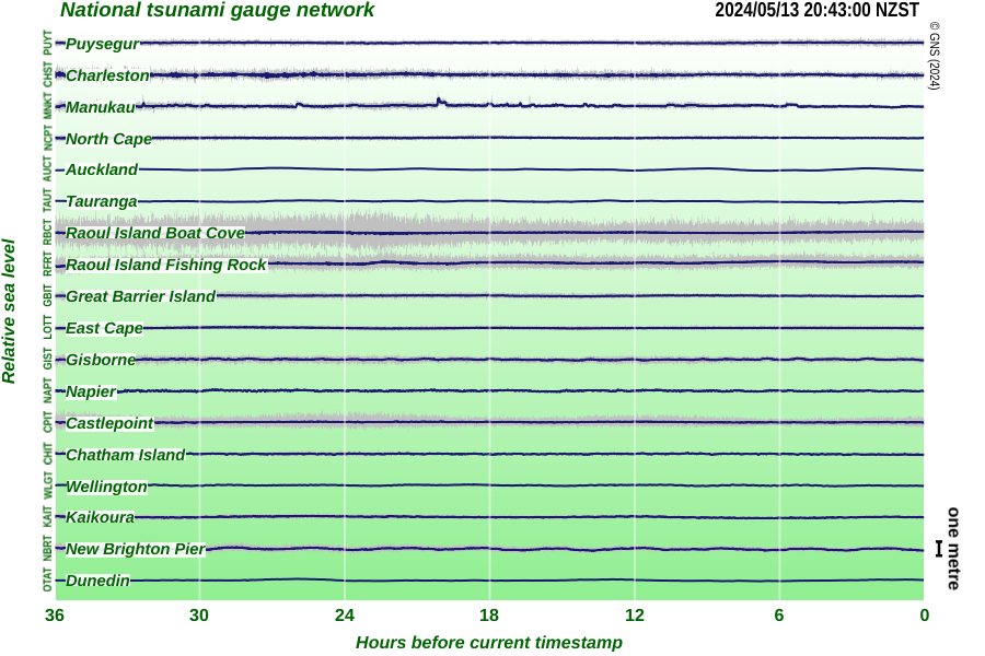
1) real-time Buoy data, for helping to determine the likelihood of a Tsunami: http://www.ndbc.noaa.gov/
Interestingly, the quake only caused a tiny change in the sea level (in the region of 5 cm's) but the expected swells on land are in the region of 3-5 meters. I believe this is because as the wave gets closer to land, it get's funneled into a smaller area, meaning the 5cm change in sea level gets amplified. Which is why it's hard for the civil service to accurately predict whether a tsunami is likely when these events occur (That, and the nearest working buoy is in Tonga), which would by why they almost always say yes, and then retract the warning later.
2) the USGS science-y explanation for what actually happened. The take-away seems to be that this may have increased the stress on the primary fault in NZ. Interestingly, their's a a suggestion that the rupture was across the hope fault, rather than along it, which helps to explain why the after shocks have been so varied (by location): http://earthquake.usgs.gov/earthquakes/eventpage/us1000778i#...
4) The Canterbury Police shared a link earlier that indicated 3-5 meter swells is around the maximum we should expect from a locally generated earthquake (due to the nature of fault lines in NZ), that's not to say we can't experience a larger tsunami, but that said tsunami would have to be generated externally (like say, south america), which should in theory give us more time to prepare. But like all things, this isn't a hard and fast rule.
5) there's a pretty cool video of what purports to be lights in the sky over wellington during the earthquake (probably has something to do with magnetic interference from the energy released by the quake): https://www.facebook.com/plugins/video.php?href=https%3A%2F%...
1) I think it was because the 5cm height is backed by a huge width, when crawling towards the land slope creates a very strong (not necessary high) wave that just keeps pushing forward.
Tsunami waves have an extremely long period. A good surfing wave forms when a swell 2-5 m amplitude with period 13-24s when it starts to feel the bottom of the ocean.
The amplitude of the tsunami wave in the open ocean is much smaller than wind-generated swells but they can have periods of 60-70 minutes so they are more of a surge that just keeps coming when they hit land, and as you say when they start to feel the bottom they stand up and the large volume of water in the wave makes it stand up larger and more powerful than you would expect for a smaller amplitude swell.
Every wave has a peak and a trough and the trough of the tsunami wave is what causes the water levels to recede so drastically before the wave hits.
Geographic features like valleys that get narrower and narrower will cause the same volume of water hitting the coast to make a much more drastic change in water level
Imagine the energy stored by lifting a kilometre-high column of water 5cm. Now imagine how high that energy can lift a 5m column of water once it reaches the coast. Obviously there is the 1/r dissipation because the circumference increases, but still, deep water lifts like this can cause a massive surge at the coast.
When I was a kid, the 1992 Big Bear Landers earthquake hit in Southern California. That was a 7.6 if I recall. So I can relate to what those in NZ are feeling. Our rock chimney collapsed and fell off the house, nearly crushing my mom who was outside at the time.
They do have employees in the South Island too (mainly Christchurch), and were looking at Birdling's Flat as a launch site. However, I imagine anyone involved in the South will also be fine -- Christchurch rolled around but didn't suffer much damage.
Nearly 2/3rds of the casualties from the 2011 earthquake were a single building that contained an ESL school, a nursing school, and a clinic - and the construction supervisor of that building wasn't actually an engineer, but had stolen a retired engineer's identity.
We have fairly comprehensive building regulations for all new housing. Our new house plans were rejected because we didn't specify strong enough straps to fix the hot water cylinder to the wall. The straps they insisted on would withstand 10 times the force experienced in the Christchurch earthquake, which was one of the most violent in terms of acceleration ever. When the big one happens, our house may be destroyed but by god the hot water cylinder will still be attached to the wall!
New Zealand in general is very quake-prone - our nickname in Victorian times was "the shaky isles". In fact our country owes it's existence to a particularly nasty intersection between the Australian and Pacific plates, with the Aussie plate slipping under the Pacific in the South Island, and vice versa in the North Island. You might think that the bit in the middle would be particularly dangerous, and you'd be right. Now guess where we built Wellington, our capital city?
Finally, there was a nice anecdote about some US hotel guests standing in the cold and dark after being evacuated from their damaged hotel. Asked if this had changed their mind about moving to NZ, they replied "Hell no, Trump is a far worse disaster than this!".
Yes, there are earthquake standards for new buildings, and mandatory retrofitting for older buildings (as they are updated).
From what I've seen, this is pretty similar to San Francisco. It would be interesting to see data comparing the standards across earthquake-prone countries/regions.
I used to work for a structural engineering company that had offices in both NZ and California, from what I understand the standards of earthquake engineering in NZ are higher than in California.
To be honest I think you're probably safer in a large earthquake in a post Christchurch NZ than in a small earthquake in a country that doesn't usually get them.
Christchurch is actually not on the fault line, and it was a surprise when such a severe earthquake hit in 2011, so they weren't well prepared. All the susceptible buildings collapsed then, and new buildings are earthquake-proof.
You're completely right. Earthquake codes save lives, but in liquefaction zones, the structures may be unlivable afterwards even if they're completely intact.
The point of earthquake codes is not that the buildings are livable in afterwards, in fact in Christchurch something like 30% of all buildings had to be demolished. The point is that they stay up long enough for rescuers to get in, and if they do collapse they collapse with survival cells rather than pancake. In Christchurch the buildings performed very well with exception of the CTV building which pancaked. Although I know that a few buildings were only seconds away from collapsing so we were very lucky.
Damn that is really scary. I used to work in Miramar (Wellington suburbs), which is built on reclaimed sea, if I recall, and everyone was freaked out that a major earthquake would liquify the entire area.
Scroll to the bottom and look at the chart of cumulative energy (moment) release over time. This is probably the easiest visualization what you're looking for without going to scientific papers. It only goes back to the 1970s though. The big steps are the Sumatran earthquakes and Tohoku (Japan). There were some equally big steps in the 1950s.
As far as I know (and I do this professionally) there is no evidence for any real variation in the global, time-averaged rate of earthquake occurrence or energy release. However the time window to average over has to be several decades to centuries depending on how comfortable one is with noise. Any individual segment of a fault will have an earthquake repeat time (for a significant earthquake) of hundreds (San Andreas fault) to tens of thousands of years, and is lots of evidence for clusters of earthquakes on individual faults or sets of faults, but this is mostly a local effect--the stress changes in the crust caused by an earthquake can basically load nearby faults and affect when they will have the next earthquake. But again, this is for the most part local (<100 km). Globally, earthquakes are essentially unrelated. That a big one may hit Chile and then Japan in short order is happenstance as far as the seismological community is concerned (though it's not dogma, and long-distance 'teleseismic' triggering is investigated--it just doesn't seem to be a big deal).
However, earthquakes in the news aren't a good reflection of global seismic statistics. Earthquakes like the Italian events (M6-6.6) over the past few months (and years) occur every day, but mostly in the ocean basins and don't affect people other than shaking some palm thatch roofs in Vanuatu. The most deadly event (minus tsunami) in my lifetime was the Haiti earthquake in 2010, killing ~200,000 people, and it was a pretty routine, moderate-magnitude event. It just hit an incredibly vulnerable population.
You're the real MVP. Thanks for your understanding of my question and the info. I get what you're saying about cumulative energy release over time and it's interesting to note the effect that earthquakes' periodicity has on how we need to sample the data. Very useful.
Not sure if suitable for your purposes, but GeoNet. They use a network of digital seismic stations. Whenever seismic waves propagate, doing a time-analysis of when they passed under each station can tell you where the quake occurred. This is augmented with crowd-sourced "felt reports".
Literally within seconds of a shake, the preliminary report hits their website, and its confidence level increases over the next few minutes as more data reports in.
I believe their online (open) data set now catalogs all NZ-region earthquake events from like the last 80 years or something. Pretty neat.
Here is the page for the big one of 6 hours ago, not to be confused with the dozens of also-large aftershocks following it:
I'm more looking for a study that tracks an increase or decrease in their intensity and magnitude over time. I would need to scientifically study and analyze the data at the link you kindly shared in order to see that.
We were evacuated and let back in. All the planning in the world doesn't prepare you for the real thing, the first thing you're meant to do is keep calm, and I sure as hell didn't. I sprinted right the fuck out of my apartment building, I have 4 levels above me, hiding under a table wasn't going to do shit to save me.
The building has some cracks in the plaster and food has fallen off all the shelves, but nothing serious. The water seems to be running a bit brown though, so maybe some damage to the water pipes.
Props to the crew at Bizdojo (http://www.bizdojo.com/) for opening an invitation for us to come and chill there if we couldn't get back into our homes. Doing the right thing there!